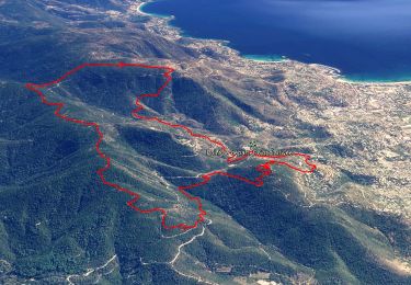
![](/images/other/stat-length.png)
![Tocht Stappen Le Lavandou - 8 plages Est du Lavandou - Photo](https://media.geolcdn.com/t/1900/400/ext.pjpeg?maxdim=2&url=https%3A%2F%2Fstatic1.geolcdn.com%2Fsiteimages%2Fupload%2Ffiles%2F1553511878bg_sport_marche.png)
8 plages Est du Lavandou
jmheydorff
Gebruiker
![Lengte](/images/other/stat-length.png)
![Max. hoogte](https://static1.geolcdn.com/siteimages/upload/files/1508320355ic_sort_altitude_max_24dp.png)
![Positief hoogteverschil](https://static1.geolcdn.com/siteimages/upload/files/1508320355ic_sort_den_pos_24dp.png)
![Km-Effort](/images/other/stat-length.png)
![Min. hoogte](https://static1.geolcdn.com/siteimages/upload/files/1508320355ic_sort_altitude_min_24dp.png)
![Negatief hoogteverschil](https://static1.geolcdn.com/siteimages/upload/files/1508320355ic_sort_den_neg_24dp.png)
![Boucle](https://static1.geolcdn.com/siteimages/upload/files/16400158638029165_repeat_loop_refresh_sync_direction_icon.png)
![Stappen](https://static1.geolcdn.com/sitytour/trail-icons/101.png)
4h37
Moeilijkheid : Gemakkelijk
![Scan deze QR-code om de tocht te openen in de SityTrail-applicatie](https://capi.geolives.com/qq0zvz2zws4bq2lad0pu/sitytour/trails/185728/qr.png?size=200)
Gratisgps-wandelapplicatie
Over ons
Tocht Stappen van 16 km beschikbaar op Provence-Alpes-Côte d'Azur, Var, Le Lavandou. Deze tocht wordt voorgesteld door jmheydorff.
Beschrijving
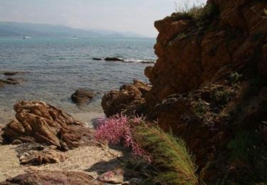
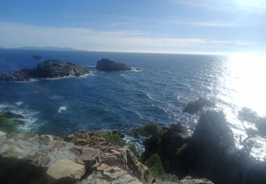
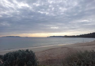
Pkg plage de St Clair,à l''Est du port du Lavandou. Partir vers les 8 plages Est (sur les 11 plages du Lavandou)
Longer la RD 559, sur la droite, côté mer, jusqu''à Pramousquier; descendre à chaque plage (St Clair, Fossette, Aiguebelle, Jean blanc et l''Elephant, Le Layet, Cavalière et Pramousquier) , puis revenir par la même route, en prenant la piste cyclable ou les petites routes //
Plaatsbepaling
Opmerkingen
Wandeltochten in de omgeving
![Tocht Stappen Bormes-les-Mimosas - SityTrail - Bormes les Mimosas - ND de Constance - Cols de Gratteloup et Landon - Photo](https://media.geolcdn.com/t/375/260/c3cd69d2-66a0-450a-95c5-e8005107dd21.jpg&format=jpg&maxdim=2)
![Stappen Stappen](https://static1.geolcdn.com/sitytour/trail-icons/101.png)
Stappen
![](/images/other/stat-length.png)
![](https://static1.geolcdn.com/siteimages/upload/files/16400158638029165_repeat_loop_refresh_sync_direction_icon.png)
![Tocht Stappen Le Lavandou - Du Lavandou à la Pointe de l'Esquillette - Photo](https://media.geolcdn.com/t/375/260/ext.jpg?maxdim=2&url=https%3A%2F%2Fservices.sitytrail.com%2FGeolivesWS%2FDownloadMedia.ashx%3FTrailID%3D105657%26Media%3D9466_6.jpg)
![Stappen Stappen](https://static1.geolcdn.com/sitytour/trail-icons/101.png)
Stappen
![](/images/other/stat-length.png)
![](https://static1.geolcdn.com/siteimages/upload/files/16400158638029165_repeat_loop_refresh_sync_direction_icon.png)
![Tocht Stappen Bormes-les-Mimosas - Bormes les Mimosas et la Forêt des Maures - Photo](https://media.geolcdn.com/t/375/260/ext.jpg?maxdim=2&url=https%3A%2F%2Fservices.sitytrail.com%2FGeolivesWS%2FDownloadMedia.ashx%3FTrailID%3D103786%26Media%3D6556_2.jpg)
![Stappen Stappen](https://static1.geolcdn.com/sitytour/trail-icons/101.png)
Stappen
![](/images/other/stat-length.png)
![](https://static1.geolcdn.com/siteimages/upload/files/16400158638029165_repeat_loop_refresh_sync_direction_icon.png)
![Tocht Stappen Bormes-les-Mimosas - Tour de Bormes - Photo](https://media.geolcdn.com/t/375/260/ext.jpg?maxdim=2&url=https%3A%2F%2Fstatic1.geolcdn.com%2Fsiteimages%2Fupload%2Ffiles%2F1553511878bg_sport_marche.png)
![Stappen Stappen](https://static1.geolcdn.com/sitytour/trail-icons/101.png)
Stappen
![](/images/other/stat-length.png)
![](https://static1.geolcdn.com/siteimages/upload/files/16400158638029165_repeat_loop_refresh_sync_direction_icon.png)
![Tocht Trail Bormes-les-Mimosas - Pointe du Diable et de Estagnol - Photo](https://media.geolcdn.com/t/375/260/ea478b0f-bf14-4a5a-bcc7-6189a705ccc7.jpg&format=jpg&maxdim=2)
![Trail Trail](https://static1.geolcdn.com/sitytour/trail-icons/104.png)
Trail
![](/images/other/stat-length.png)
![](https://static1.geolcdn.com/siteimages/upload/files/16400158638029165_repeat_loop_refresh_sync_direction_icon.png)
![Tocht Stappen Le Lavandou - Balcons de Pramousquier 22.1.23 - Photo](https://media.geolcdn.com/t/375/260/b49f05a7-2e02-450b-a614-7cc169048d9c.jpg&format=jpg&maxdim=2)
![Stappen Stappen](https://static1.geolcdn.com/sitytour/trail-icons/101.png)
Stappen
![](/images/other/stat-length.png)
![](https://static1.geolcdn.com/siteimages/upload/files/16400158638029165_repeat_loop_refresh_sync_direction_icon.png)
![Tocht Stappen Bormes-les-Mimosas - Bormes les Mimosas Les 3 Cols - Photo](https://media.geolcdn.com/t/375/260/23bdb278-92e8-4d98-83cb-eb5b5435fc48.jpg&format=jpg&maxdim=2)
![Stappen Stappen](https://static1.geolcdn.com/sitytour/trail-icons/101.png)
Stappen
![](/images/other/stat-length.png)
![](https://static1.geolcdn.com/siteimages/upload/files/16400158638029165_repeat_loop_refresh_sync_direction_icon.png)
![Tocht Stappen Bormes-les-Mimosas - Col du Gratteloup - Piste domaniale Sud - Cols de Labade et Landon - Pierre d'Avenon - GR51/90 - Photo](https://media.geolcdn.com/t/375/260/a68a068d-d9c5-4471-8f2a-bbfabcb93eed.jpg&format=jpg&maxdim=2)
![Stappen Stappen](https://static1.geolcdn.com/sitytour/trail-icons/101.png)
Stappen
![](/images/other/stat-length.png)
![](https://static1.geolcdn.com/siteimages/upload/files/16400158638029165_repeat_loop_refresh_sync_direction_icon.png)
![Tocht Stappen Le Lavandou - cavaliere - Photo](https://media.geolcdn.com/t/375/260/ext.jpg?maxdim=2&url=https%3A%2F%2Fstatic1.geolcdn.com%2Fsiteimages%2Fupload%2Ffiles%2F1553511878bg_sport_marche.png)
![Stappen Stappen](https://static1.geolcdn.com/sitytour/trail-icons/101.png)
Stappen
![](/images/other/stat-length.png)
![](https://static1.geolcdn.com/siteimages/upload/files/16400158638029165_repeat_loop_refresh_sync_direction_icon.png)